


running 3

baclaude
User
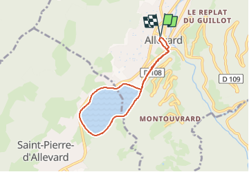

Length
6.1 km

Max alt
536 m

Uphill gradient
107 m
Km-Effort
7.5 km

Min alt
466 m

Downhill gradient
107 m
Boucle
Yes
Creation date :
2024-08-15 15:31:54.891
Updated on :
2024-08-16 17:08:52.921
34m
Difficulty : Medium

FREE GPS app for hiking
 SityTrail
IGN / Geographical institutes
SityTrail Plus
The world is yours!
About
Trail Running of 6.1 km to be discovered at Auvergne-Rhône-Alpes, Isère, Allevard. This trail is proposed by baclaude.
Positioning
Country:
France
Region :
Auvergne-Rhône-Alpes
Department/Province :
Isère
Municipality :
Allevard
Location:
Unknown
Start:(Dec)
Start:(UTM)
270953 ; 5030893 (32T) N.
Comments