


Chamriand

Iahns
User
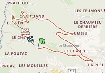

Length
3.2 km

Max alt
1024 m

Uphill gradient
173 m
Km-Effort
5.5 km

Min alt
854 m

Downhill gradient
170 m
Boucle
Yes
Creation date :
2024-08-17 10:52:14.095
Updated on :
2024-08-17 12:43:50.533
1h13
Difficulty : Easy

FREE GPS app for hiking
 SityTrail
IGN / Geographical institutes
SityTrail Plus
The world is yours!
About
Trail Walking of 3.2 km to be discovered at Auvergne-Rhône-Alpes, Upper Savoy, Verchaix. This trail is proposed by Iahns.
Positioning
Country:
France
Region :
Auvergne-Rhône-Alpes
Department/Province :
Upper Savoy
Municipality :
Verchaix
Location:
Unknown
Start:(Dec)
Start:(UTM)
319884 ; 5107705 (32T) N.
Comments