


Ceillac à St Véran

ARVIEU
User
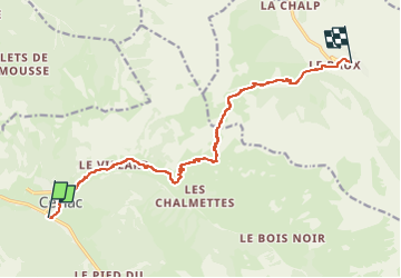

Length
12.8 km

Max alt
2648 m

Uphill gradient
1166 m
Km-Effort
27 km

Min alt
1633 m

Downhill gradient
810 m
Boucle
No
Creation date :
2024-08-17 16:38:16.093
Updated on :
2024-08-17 16:39:06.364
6h00
Difficulty : Difficult

FREE GPS app for hiking
 SityTrail
IGN / Geographical institutes
SityTrail Plus
The world is yours!
About
Trail Walking of 12.8 km to be discovered at Provence-Alpes-Côte d'Azur, Hautes-Alpes, Ceillac. This trail is proposed by ARVIEU.
Positioning
Country:
France
Region :
Provence-Alpes-Côte d'Azur
Department/Province :
Hautes-Alpes
Municipality :
Ceillac
Location:
Unknown
Start:(Dec)
Start:(UTM)
323566 ; 4948146 (32T) N.
Comments