


Refuge Agnel au Refuge de la Monta

ARVIEU
User
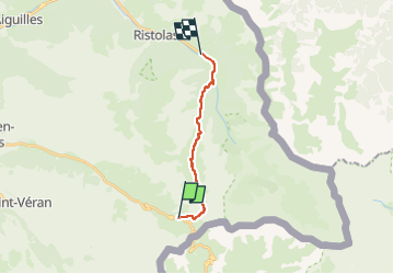

Length
11.5 km

Max alt
2809 m

Uphill gradient
278 m
Km-Effort
18.2 km

Min alt
1671 m

Downhill gradient
1177 m
Boucle
No
Creation date :
2024-08-17 16:50:59.317
Updated on :
2024-08-21 10:05:57.252
4h30
Difficulty : Difficult

FREE GPS app for hiking
 SityTrail
IGN / Geographical institutes
SityTrail Plus
The world is yours!
About
Trail Walking of 11.5 km to be discovered at Provence-Alpes-Côte d'Azur, Hautes-Alpes, Molines-en-Queyras. This trail is proposed by ARVIEU.
Description
nb: variante possible par le Pain de Sucre (3208 m)
Photos

Positioning
Country:
France
Region :
Provence-Alpes-Côte d'Azur
Department/Province :
Hautes-Alpes
Municipality :
Molines-en-Queyras
Location:
Unknown
Start:(Dec)
Start:(UTM)
339162 ; 4950777 (32T) N.
Comments