


03.05.2015 - CORBINIÈRES fin

babeth35
User
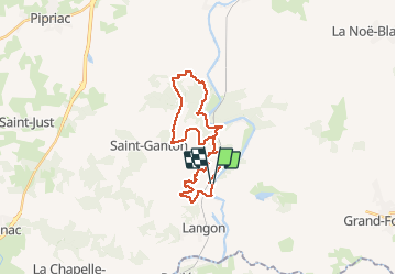

Length
26 km

Max alt
101 m

Uphill gradient
525 m
Km-Effort
33 km

Min alt
3 m

Downhill gradient
517 m
Boucle
Yes
Creation date :
2015-05-03 00:00:00.0
Updated on :
2020-07-20 15:55:10.396
6h37
Difficulty : Medium

FREE GPS app for hiking
 SityTrail
IGN / Geographical institutes
SityTrail Plus
The world is yours!
About
Trail Walking of 26 km to be discovered at Brittany, Ille-et-Vilaine, Langon. This trail is proposed by babeth35.
Positioning
Country:
France
Region :
Brittany
Department/Province :
Ille-et-Vilaine
Municipality :
Langon
Location:
Unknown
Start:(Dec)
Start:(UTM)
586697 ; 5288001 (30T) N.
Comments