


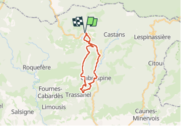
Pradelles Cabardès

tercla
User

Length
21 km

Max alt
911 m

Uphill gradient
890 m
Km-Effort
33 km

Min alt
311 m

Downhill gradient
890 m
Boucle
Yes
Creation date :
2024-08-18 07:30:33.837
Updated on :
2024-08-18 14:47:30.572
7h13
Difficulty : Very difficult

FREE GPS app for hiking
 SityTrail
IGN / Geographical institutes
SityTrail Plus
The world is yours!
About
Trail Walking of 21 km to be discovered at Occitania, Aude, Pradelles-Cabardès. This trail is proposed by tercla.
Photos


23 photos in total. Please click on a photo to see them all in the gallery.
Positioning
Country:
France
Region :
Occitania
Department/Province :
Aude
Municipality :
Pradelles-Cabardès
Location:
Unknown
Start:(Dec)
Start:(UTM)
455094 ; 4806244 (31T) N.
Comments