


seix saint lizier

MERMOZ33
User
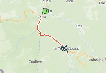

Length
12 km

Max alt
752 m

Uphill gradient
323 m
Km-Effort
15.6 km

Min alt
510 m

Downhill gradient
91 m
Boucle
No
Creation date :
2024-08-19 10:50:32.187
Updated on :
2024-08-19 10:50:36.528
3h32
Difficulty : Difficult

FREE GPS app for hiking
 SityTrail
IGN / Geographical institutes
SityTrail Plus
The world is yours!
About
Trail Walking of 12 km to be discovered at Occitania, Ariège, Seix. This trail is proposed by MERMOZ33.
Positioning
Country:
France
Region :
Occitania
Department/Province :
Ariège
Municipality :
Seix
Location:
Unknown
Start:(Dec)
Start:(UTM)
353048 ; 4747169 (31T) N.
Comments