


20230819 Ver les Chartres

Jeanclaudebic
User
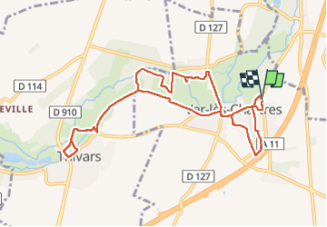

Length
10.3 km

Max alt
143 m

Uphill gradient
68 m
Km-Effort
11.2 km

Min alt
131 m

Downhill gradient
68 m
Boucle
Yes
Creation date :
2024-08-19 11:55:58.476
Updated on :
2024-08-19 15:03:03.89
2h32
Difficulty : Medium

FREE GPS app for hiking
 SityTrail
IGN / Geographical institutes
SityTrail Plus
The world is yours!
About
Trail Walking of 10.3 km to be discovered at Centre-Loire Valley, Eure-et-Loir, Ver-lès-Chartres. This trail is proposed by Jeanclaudebic.
Positioning
Country:
France
Region :
Centre-Loire Valley
Department/Province :
Eure-et-Loir
Municipality :
Ver-lès-Chartres
Location:
Unknown
Start:(Dec)
Start:(UTM)
387871 ; 5360416 (31U) N.
Comments