


ATF-01-07-2024 du 21.07.2024

bene_dictus77
User

Length
17.1 km

Max alt
188 m

Uphill gradient
369 m
Km-Effort
22 km

Min alt
50 m

Downhill gradient
369 m
Boucle
No
Creation date :
2024-07-21 07:33:43.619
Updated on :
2024-08-20 14:41:21.683
5h49
Difficulty : Easy

FREE GPS app for hiking
 SityTrail
IGN / Geographical institutes
SityTrail Plus
The world is yours!
About
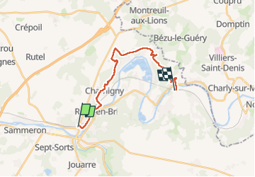
Trail Walking of 17.1 km to be discovered at Ile-de-France, Seine-et-Marne, La Ferté-sous-Jouarre. This trail is proposed by bene_dictus77.
Description
de la Ferté sous Jouarre à Nanteuil-Saacy
Positioning
Country:
France
Region :
Ile-de-France
Department/Province :
Seine-et-Marne
Municipality :
La Ferté-sous-Jouarre
Location:
Unknown
Start:(Dec)
Start:(UTM)
509203 ; 5421977 (31U) N.
Comments