


orient ternis saint sernin

pcabot
User
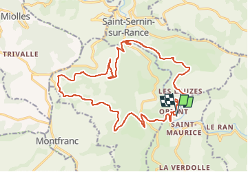

Length
23 km

Max alt
704 m

Uphill gradient
634 m
Km-Effort
31 km

Min alt
300 m

Downhill gradient
632 m
Boucle
Yes
Creation date :
2024-08-20 13:56:20.86
Updated on :
2024-08-20 15:34:48.794
1h38
Difficulty : Medium

FREE GPS app for hiking
 SityTrail
IGN / Geographical institutes
SityTrail Plus
The world is yours!
About
Trail Mountain bike of 23 km to be discovered at Occitania, Aveyron, Laval-Roquecezière. This trail is proposed by pcabot.
Positioning
Country:
France
Region :
Occitania
Department/Province :
Aveyron
Municipality :
Laval-Roquecezière
Location:
Unknown
Start:(Dec)
Start:(UTM)
470059 ; 4855535 (31T) N.
Comments