


Rallye d'Autun Sud Morvan La Chataigne 2024 - ES1

i20
User
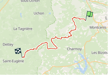

Length
23 km

Max alt
465 m

Uphill gradient
357 m
Km-Effort
29 km

Min alt
306 m

Downhill gradient
509 m
Boucle
No
Creation date :
2024-08-20 20:59:16.708
Updated on :
2024-08-20 21:00:06.573
0m
Difficulty : Very easy

FREE GPS app for hiking
 SityTrail
IGN / Geographical institutes
SityTrail Plus
The world is yours!
About
Trail Car of 23 km to be discovered at Bourgogne-Franche-Comté, Saône-et-Loire, Montcenis. This trail is proposed by i20.
Positioning
Country:
France
Region :
Bourgogne-Franche-Comté
Department/Province :
Saône-et-Loire
Municipality :
Montcenis
Location:
Unknown
Start:(Dec)
Start:(UTM)
603771 ; 5183879 (31T) N.
Comments