


Manosque VAE tour 2

phugues
User
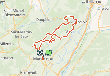

Length
42 km

Max alt
787 m

Uphill gradient
1348 m
Km-Effort
60 km

Min alt
335 m

Downhill gradient
1344 m
Boucle
Yes
Creation date :
2024-08-21 07:03:26.415
Updated on :
2024-08-21 10:12:13.905
3h08
Difficulty : Very difficult

FREE GPS app for hiking
 SityTrail
IGN / Geographical institutes
SityTrail Plus
The world is yours!
About
Trail Mountain bike of 42 km to be discovered at Provence-Alpes-Côte d'Azur, Alpes-de-Haute-Provence, Manosque. This trail is proposed by phugues.
Positioning
Country:
France
Region :
Provence-Alpes-Côte d'Azur
Department/Province :
Alpes-de-Haute-Provence
Municipality :
Manosque
Location:
Unknown
Start:(Dec)
Start:(UTM)
723966 ; 4857073 (31T) N.
Comments