


Test

olivieraron
User

Length
256 m

Max alt
569 m

Uphill gradient
5 m
Km-Effort
319 m

Min alt
561 m

Downhill gradient
4 m
Boucle
Yes
Creation date :
2024-08-21 10:53:01.0
Updated on :
2024-08-21 10:53:04.933
4m
Difficulty : Easy

FREE GPS app for hiking
 SityTrail
IGN / Geographical institutes
SityTrail Plus
The world is yours!
About
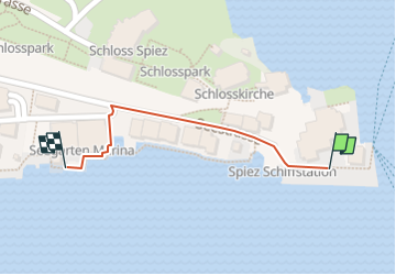
Trail Walking of 256 m to be discovered at Bern, Frutigen-Niedersimmental administrative district, Spiez. This trail is proposed by olivieraron.
Positioning
Country:
Switzerland
Region :
Bern
Department/Province :
Frutigen-Niedersimmental administrative district
Municipality :
Spiez
Location:
Unknown
Start:(Dec)
Start:(UTM)
399786 ; 5171381 (32T) N.
Comments