


balade des taons

Alain Gasnot
User
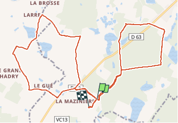

Length
16 km

Max alt
121 m

Uphill gradient
117 m
Km-Effort
17.6 km

Min alt
93 m

Downhill gradient
117 m
Boucle
No
Creation date :
2024-04-07 09:02:31.596
Updated on :
2024-08-21 11:20:21.727
2h52
Difficulty : Easy

FREE GPS app for hiking
 SityTrail
IGN / Geographical institutes
SityTrail Plus
The world is yours!
About
Trail Horseback riding of 16 km to be discovered at Centre-Loire Valley, Loir-et-Cher, Mur-de-Sologne. This trail is proposed by Alain Gasnot.
Positioning
Country:
France
Region :
Centre-Loire Valley
Department/Province :
Loir-et-Cher
Municipality :
Mur-de-Sologne
Location:
Unknown
Start:(Dec)
Start:(UTM)
392595 ; 5249191 (31T) N.
Comments