


Col d'Aumar Lac Supérieur Col de Gourguet Lac de l'ours Lac de l'île Col d'Aumar

JMFr
User
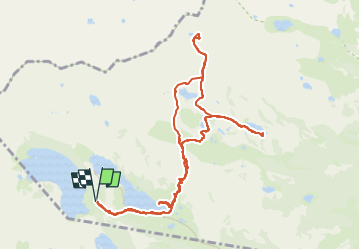

Length
11.7 km

Max alt
2474 m

Uphill gradient
543 m
Km-Effort
19 km

Min alt
2168 m

Downhill gradient
542 m
Boucle
Yes
Creation date :
2024-07-27 06:41:21.07
Updated on :
2024-08-21 13:37:14.574
3h26
Difficulty : Medium

FREE GPS app for hiking
 SityTrail
IGN / Geographical institutes
SityTrail Plus
The world is yours!
About
Trail Walking of 11.7 km to be discovered at Occitania, Hautespyrenees, Vielle-Aure. This trail is proposed by JMFr.
Positioning
Country:
France
Region :
Occitania
Department/Province :
Hautespyrenees
Municipality :
Vielle-Aure
Location:
Unknown
Start:(Dec)
Start:(UTM)
266655 ; 4747053 (31T) N.
Comments