


Garde-Colombe St genis savournon jubeo VTT 40k 729m

Danielba
User GUIDE
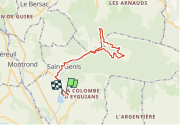

Length
17 km

Max alt
962 m

Uphill gradient
433 m
Km-Effort
23 km

Min alt
635 m

Downhill gradient
440 m
Boucle
Yes
Creation date :
2024-08-21 07:53:32.236
Updated on :
2024-08-23 18:11:40.552
5h58
Difficulty : Easy

FREE GPS app for hiking
 SityTrail
IGN / Geographical institutes
SityTrail Plus
The world is yours!
About
Trail Walking of 17 km to be discovered at Provence-Alpes-Côte d'Azur, Hautes-Alpes, Garde-Colombe. This trail is proposed by Danielba .
Positioning
Country:
France
Region :
Provence-Alpes-Côte d'Azur
Department/Province :
Hautes-Alpes
Municipality :
Garde-Colombe
Location:
Eyguians
Start:(Dec)
Start:(UTM)
720829 ; 4916403 (31T) N.
Comments