


SityTrail - Aix en Othe St Mards en othe et les hameaux

fasbi67
User
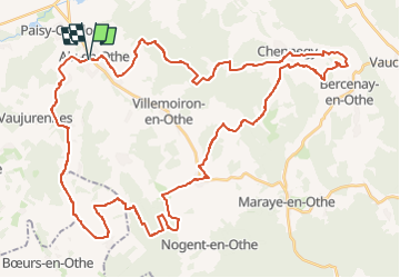

Length
54 km

Max alt
254 m

Uphill gradient
904 m
Km-Effort
66 km

Min alt
130 m

Downhill gradient
903 m
Boucle
Yes
Creation date :
2024-08-21 19:33:54.471
Updated on :
2024-08-21 19:35:07.625

FREE GPS app for hiking
 SityTrail
IGN / Geographical institutes
SityTrail Plus
The world is yours!
About
Trail of 54 km to be discovered at Grand Est, Aube, Aix-Villemaur-Pâlis. This trail is proposed by fasbi67.
Positioning
Country:
France
Region :
Grand Est
Department/Province :
Aube
Municipality :
Aix-Villemaur-Pâlis
Location:
Aix-en-Othe
Start:(Dec)
Start:(UTM)
554284 ; 5341234 (31U) N.
Comments