


3 Yser

patdecosnes
User

Length
11.4 km

Max alt
66 m

Uphill gradient
93 m
Km-Effort
12.7 km

Min alt
15 m

Downhill gradient
89 m
Boucle
No
Creation date :
2024-08-22 07:04:54.0
Updated on :
2024-08-22 09:37:43.415
2h24
Difficulty : Difficult

FREE GPS app for hiking
 SityTrail
IGN / Geographical institutes
SityTrail Plus
The world is yours!
About
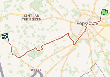
Trail Walking of 11.4 km to be discovered at Flanders, West Flanders, Poperinge. This trail is proposed by patdecosnes.
Positioning
Country:
Belgium
Region :
Flanders
Department/Province :
West Flanders
Municipality :
Poperinge
Location:
Poperinge
Start:(Dec)
Start:(UTM)
481770 ; 5634111 (31U) N.
Comments