


lac belledonne

Liebeaux
User
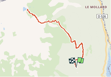

Length
12 km

Max alt
2176 m

Uphill gradient
922 m
Km-Effort
24 km

Min alt
1277 m

Downhill gradient
922 m
Boucle
Yes
Creation date :
2024-08-22 06:27:34.865
Updated on :
2024-08-22 14:18:36.451
7h50
Difficulty : Very difficult

FREE GPS app for hiking
 SityTrail
IGN / Geographical institutes
SityTrail Plus
The world is yours!
About
Trail Walking of 12 km to be discovered at Auvergne-Rhône-Alpes, Isère, Allemond. This trail is proposed by Liebeaux.
Positioning
Country:
France
Region :
Auvergne-Rhône-Alpes
Department/Province :
Isère
Municipality :
Allemond
Location:
Unknown
Start:(Dec)
Start:(UTM)
266336 ; 5003044 (32T) N.
Comments