


Pont d'Ouilly

VANDERPUTTENMi
User GUIDE
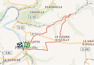

Length
7.4 km

Max alt
207 m

Uphill gradient
218 m
Km-Effort
10.3 km

Min alt
48 m

Downhill gradient
218 m
Boucle
Yes
Creation date :
2024-08-23 14:49:15.394
Updated on :
2024-08-23 14:50:37.235
2h20
Difficulty : Medium

FREE GPS app for hiking
 SityTrail
IGN / Geographical institutes
SityTrail Plus
The world is yours!
About
Trail Walking of 7.4 km to be discovered at Normandy, Calvados, Pont-d'Ouilly. This trail is proposed by VANDERPUTTENMi.
Positioning
Country:
France
Region :
Normandy
Department/Province :
Calvados
Municipality :
Pont-d'Ouilly
Location:
Unknown
Start:(Dec)
Start:(UTM)
689805 ; 5416575 (30U) N.
Comments