


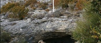
Plateau de Calern - Grottes et chapelle souterraine

jlrayon
User
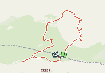

Length
11.7 km

Max alt
1284 m

Uphill gradient
267 m
Km-Effort
15.3 km

Min alt
1116 m

Downhill gradient
269 m
Boucle
Yes
Creation date :
2015-05-05 00:00:00.0
Updated on :
2021-11-08 17:14:41.88
3h47
Difficulty : Medium

FREE GPS app for hiking
 SityTrail
IGN / Geographical institutes
SityTrail Plus
The world is yours!
About
Trail Walking of 11.7 km to be discovered at Provence-Alpes-Côte d'Azur, Maritime Alps, Caussols. This trail is proposed by jlrayon.
Description
Parking de l'Observatoire, Grotte Aven des Baudillouns, Grotte du Tombeau, Aven de l' Enclos, Aven Moustique Chapelle souterraine N.D. de Calern, Retour à l'Observatoire
Photos


Positioning
Country:
France
Region :
Provence-Alpes-Côte d'Azur
Department/Province :
Maritime Alps
Municipality :
Caussols
Location:
Unknown
Start:(Dec)
Start:(UTM)
332879 ; 4846344 (32T) N.
Comments