


Le Saint Mont

JeanPierreNancy
User
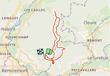

Length
14.9 km

Max alt
797 m

Uphill gradient
527 m
Km-Effort
22 km

Min alt
486 m

Downhill gradient
537 m
Boucle
Yes
Creation date :
2024-08-24 07:25:00.188
Updated on :
2024-08-24 14:01:52.215
6h24
Difficulty : Medium

FREE GPS app for hiking
 SityTrail
IGN / Geographical institutes
SityTrail Plus
The world is yours!
About
Trail Mountain bike of 14.9 km to be discovered at Grand Est, Vosges, Saint-Étienne-lès-Remiremont. This trail is proposed by JeanPierreNancy.
Positioning
Country:
France
Region :
Grand Est
Department/Province :
Vosges
Municipality :
Saint-Étienne-lès-Remiremont
Location:
Unknown
Start:(Dec)
Start:(UTM)
322958 ; 5321818 (32U) N.
Comments