


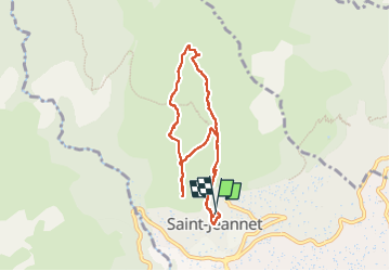
Tour baou de saint jeannet

Arnaud Stévenard
User

Length
7.9 km

Max alt
817 m

Uphill gradient
427 m
Km-Effort
13.6 km

Min alt
435 m

Downhill gradient
437 m
Boucle
Yes
Creation date :
2024-08-25 05:48:03.0
Updated on :
2024-08-25 08:20:03.089
2h30
Difficulty : Easy

FREE GPS app for hiking
 SityTrail
IGN / Geographical institutes
SityTrail Plus
The world is yours!
About
Trail Walking of 7.9 km to be discovered at Provence-Alpes-Côte d'Azur, Maritime Alps, Saint-Jeannet. This trail is proposed by Arnaud Stévenard.
Positioning
Country:
France
Region :
Provence-Alpes-Côte d'Azur
Department/Province :
Maritime Alps
Municipality :
Saint-Jeannet
Location:
Unknown
Start:(Dec)
Start:(UTM)
350470 ; 4845657 (32T) N.
Comments