


ottrott

apa
User
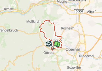

Length
19.3 km

Max alt
372 m

Uphill gradient
354 m
Km-Effort
24 km

Min alt
210 m

Downhill gradient
357 m
Boucle
Yes
Creation date :
2024-08-25 08:49:30.598
Updated on :
2024-08-25 10:23:27.445
1h33
Difficulty : Medium

FREE GPS app for hiking
 SityTrail
IGN / Geographical institutes
SityTrail Plus
The world is yours!
About
Trail Mountain bike of 19.3 km to be discovered at Grand Est, Bas-Rhin, Obernai. This trail is proposed by apa.
Photos


Positioning
Country:
France
Region :
Grand Est
Department/Province :
Bas-Rhin
Municipality :
Obernai
Location:
Unknown
Start:(Dec)
Start:(UTM)
384234 ; 5368713 (32U) N.
Comments