


Nans sous Ste Anne 20240825

cmike39
User
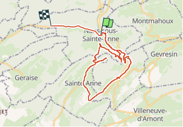

Length
19.6 km

Max alt
694 m

Uphill gradient
733 m
Km-Effort
29 km

Min alt
362 m

Downhill gradient
597 m
Boucle
No
Creation date :
2024-08-25 06:58:36.838
Updated on :
2024-08-25 14:19:55.078
7h19
Difficulty : Very difficult

FREE GPS app for hiking
 SityTrail
IGN / Geographical institutes
SityTrail Plus
The world is yours!
About
Trail Walking of 19.6 km to be discovered at Bourgogne-Franche-Comté, Doubs, Nans-sous-Sainte-Anne. This trail is proposed by cmike39.
Positioning
Country:
France
Region :
Bourgogne-Franche-Comté
Department/Province :
Doubs
Municipality :
Nans-sous-Sainte-Anne
Location:
Unknown
Start:(Dec)
Start:(UTM)
728090 ; 5206957 (31T) N.
Comments