


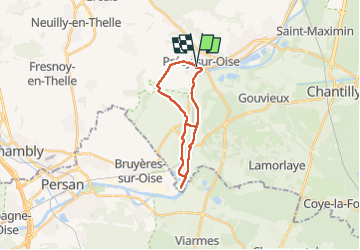
Percy sur Oise

jpblimond
User

Length
17.5 km

Max alt
112 m

Uphill gradient
168 m
Km-Effort
19.8 km

Min alt
21 m

Downhill gradient
170 m
Boucle
Yes
Creation date :
2024-08-25 11:01:38.0
Updated on :
2024-08-25 15:10:32.056
4h08
Difficulty : Medium

FREE GPS app for hiking
 SityTrail
IGN / Geographical institutes
SityTrail Plus
The world is yours!
About
Trail Walking of 17.5 km to be discovered at Hauts-de-France, Oise, Précy-sur-Oise. This trail is proposed by jpblimond.
Positioning
Country:
France
Region :
Hauts-de-France
Department/Province :
Oise
Municipality :
Précy-sur-Oise
Location:
Unknown
Start:(Dec)
Start:(UTM)
454029 ; 5450332 (31U) N.
Comments