


La balingue

viaul
User GUIDE
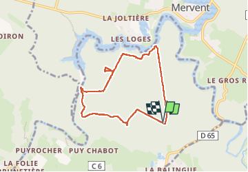

Length
6.9 km

Max alt
105 m

Uphill gradient
151 m
Km-Effort
8.9 km

Min alt
24 m

Downhill gradient
147 m
Boucle
Yes
Creation date :
2024-08-25 13:18:23.0
Updated on :
2024-08-25 15:11:58.376

FREE GPS app for hiking
 SityTrail
IGN / Geographical institutes
SityTrail Plus
The world is yours!
About
Trail of 6.9 km to be discovered at Pays de la Loire, Vendée, L'Orbrie. This trail is proposed by viaul.
Positioning
Country:
France
Region :
Pays de la Loire
Department/Province :
Vendée
Municipality :
L'Orbrie
Location:
Unknown
Start:(Dec)
Start:(UTM)
671746 ; 5152405 (30T) N.
Comments