


Tour du lac Miribel 20240827

Valery01
User
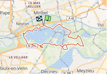

Length
18.4 km

Max alt
189 m

Uphill gradient
137 m
Km-Effort
20 km

Min alt
170 m

Downhill gradient
139 m
Boucle
Yes
Creation date :
2024-08-27 10:10:08.0
Updated on :
2024-08-27 11:12:43.826
1h02
Difficulty : Medium

FREE GPS app for hiking
 SityTrail
IGN / Geographical institutes
SityTrail Plus
The world is yours!
About
Trail Mountain bike of 18.4 km to be discovered at Auvergne-Rhône-Alpes, Ain, Miribel. This trail is proposed by Valery01.
Positioning
Country:
France
Region :
Auvergne-Rhône-Alpes
Department/Province :
Ain
Municipality :
Miribel
Location:
Unknown
Start:(Dec)
Start:(UTM)
652019 ; 5075204 (31T) N.
Comments