


balade vers Tiolache depuis Pré Râteau 27 08 2024

bymarc26
User
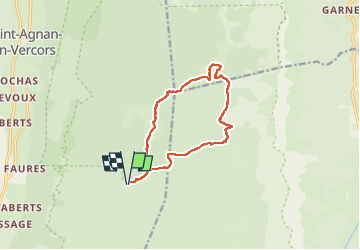

Length
12.6 km

Max alt
1667 m

Uphill gradient
357 m
Km-Effort
17.3 km

Min alt
1438 m

Downhill gradient
357 m
Boucle
Yes
Creation date :
2024-08-27 07:54:26.494
Updated on :
2024-08-28 11:31:05.28
3h57
Difficulty : Medium

FREE GPS app for hiking
 SityTrail
IGN / Geographical institutes
SityTrail Plus
The world is yours!
About
Trail Walking of 12.6 km to be discovered at Auvergne-Rhône-Alpes, Drôme, Saint-Agnan-en-Vercors. This trail is proposed by bymarc26.
Photos


Positioning
Country:
France
Region :
Auvergne-Rhône-Alpes
Department/Province :
Drôme
Municipality :
Saint-Agnan-en-Vercors
Location:
Unknown
Start:(Dec)
Start:(UTM)
694818 ; 4974863 (31T) N.
Comments