


maison 8 par le col

Philovic
User

Length
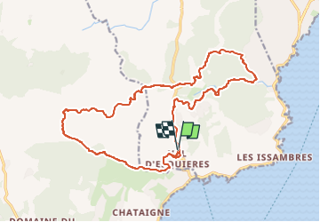
21 km

Max alt
238 m

Uphill gradient
596 m
Km-Effort
29 km

Min alt
11 m

Downhill gradient
594 m
Boucle
Yes
Creation date :
2024-08-21 05:55:58.244
Updated on :
2024-08-28 15:28:05.787
2h02
Difficulty : Medium

FREE GPS app for hiking
 SityTrail
IGN / Geographical institutes
SityTrail Plus
The world is yours!
About
Trail Mountain bike of 21 km to be discovered at Provence-Alpes-Côte d'Azur, Var, Roquebrune-sur-Argens. This trail is proposed by Philovic.
Positioning
Country:
France
Region :
Provence-Alpes-Côte d'Azur
Department/Province :
Var
Municipality :
Roquebrune-sur-Argens
Location:
Unknown
Start:(Dec)
Start:(UTM)
311569 ; 4802208 (32T) N.
Comments
Belle randonnée. Une descente un peu technique