


St Hippolyte du fort Col du Mercou l'Estrechure Col de l'Asclier Sumène

ARVIEU
User

Length
74 km

Max alt
904 m

Uphill gradient
1636 m
Km-Effort
96 km

Min alt
172 m

Downhill gradient
1636 m
Boucle
Yes
Creation date :
2024-08-30 08:25:48.166
Updated on :
2024-08-30 08:28:09.788
5h00
Difficulty : Difficult

FREE GPS app for hiking
 SityTrail
IGN / Geographical institutes
SityTrail Plus
The world is yours!
About
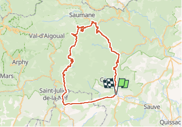
Trail Road bike of 74 km to be discovered at Occitania, Gard, Saint-Hippolyte-du-Fort. This trail is proposed by ARVIEU.
Description
Départ de St Hippolyte du Fort Col du Mercou l'Estrechure Col de l'Asclier Sumène retour à St Hippo par la voie verte
Positioning
Country:
France
Region :
Occitania
Department/Province :
Gard
Municipality :
Saint-Hippolyte-du-Fort
Location:
Unknown
Start:(Dec)
Start:(UTM)
568590 ; 4868288 (31T) N.
Comments