


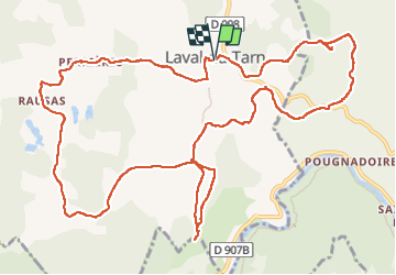
Laval du Tarn /Mont Rose

tyntyn
User

Length
15.7 km

Max alt
902 m

Uphill gradient
434 m
Km-Effort
22 km

Min alt
785 m

Downhill gradient
432 m
Boucle
Yes
Creation date :
2024-08-30 08:18:08.95
Updated on :
2024-08-30 13:20:26.037
4h35
Difficulty : Medium

FREE GPS app for hiking
 SityTrail
IGN / Geographical institutes
SityTrail Plus
The world is yours!
About
Trail Walking of 15.7 km to be discovered at Occitania, Lozère, Laval-du-Tarn. This trail is proposed by tyntyn.
Positioning
Country:
France
Region :
Occitania
Department/Province :
Lozère
Municipality :
Laval-du-Tarn
Location:
Unknown
Start:(Dec)
Start:(UTM)
528072 ; 4911192 (31T) N.
Comments