


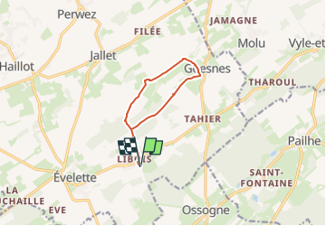
Libois-Goesnes-8km

dejongm
User

Length
8 km

Max alt
285 m

Uphill gradient
140 m
Km-Effort
9.9 km

Min alt
211 m

Downhill gradient
140 m
Boucle
Yes
Creation date :
2024-08-31 11:03:30.207
Updated on :
2024-08-31 11:05:27.426
2h15
Difficulty : Medium

FREE GPS app for hiking
 SityTrail
IGN / Geographical institutes
SityTrail Plus
The world is yours!
About
Trail Walking of 8 km to be discovered at Wallonia, Namur, Ohey. This trail is proposed by dejongm.
Description
Départ de la rando à Libois à la chapelle Saint Hubert
Positioning
Country:
Belgium
Region :
Wallonia
Department/Province :
Namur
Municipality :
Ohey
Location:
Unknown
Start:(Dec)
Start:(UTM)
656064 ; 5587214 (31U) N.
Comments