


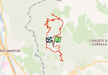
Sentier des gardes et Harkis

veroarvinberod
User

Length
12.2 km

Max alt
1683 m

Uphill gradient
1037 m
Km-Effort
26 km

Min alt
1021 m

Downhill gradient
1059 m
Boucle
Yes
Creation date :
2024-08-31 10:17:26.839
Updated on :
2024-08-31 17:33:39.816
5h55
Difficulty : Very difficult

FREE GPS app for hiking
 SityTrail
IGN / Geographical institutes
SityTrail Plus
The world is yours!
About
Trail Walking of 12.2 km to be discovered at Auvergne-Rhône-Alpes, Upper Savoy, Passy. This trail is proposed by veroarvinberod.
Positioning
Country:
France
Region :
Auvergne-Rhône-Alpes
Department/Province :
Upper Savoy
Municipality :
Passy
Location:
Unknown
Start:(Dec)
Start:(UTM)
319336 ; 5090279 (32T) N.
Comments