


Mollkirch-Hohbühl

AgnesPollux
User
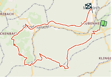

Length
26 km

Max alt
779 m

Uphill gradient
790 m
Km-Effort
36 km

Min alt
299 m

Downhill gradient
840 m
Boucle
No
Creation date :
2024-08-31 07:56:31.918
Updated on :
2024-08-31 15:01:52.523
7h04
Difficulty : Difficult

FREE GPS app for hiking
 SityTrail
IGN / Geographical institutes
SityTrail Plus
The world is yours!
About
Trail Horseback riding of 26 km to be discovered at Grand Est, Bas-Rhin, Rosheim. This trail is proposed by AgnesPollux.
Description
Randonnee à cheval, Difficulté moyenne, 27km, 6h
Positioning
Country:
France
Region :
Grand Est
Department/Province :
Bas-Rhin
Municipality :
Rosheim
Location:
Unknown
Start:(Dec)
Start:(UTM)
381397 ; 5372041 (32U) N.
Comments