


Baclain route langlire

jpbrion
User
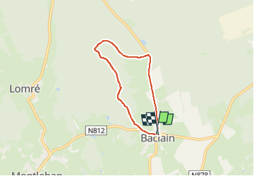

Length
4.7 km

Max alt
537 m

Uphill gradient
106 m
Km-Effort
6.1 km

Min alt
453 m

Downhill gradient
105 m
Boucle
Yes
Creation date :
2024-08-31 13:58:30.0
Updated on :
2024-08-31 15:36:01.454
1h24
Difficulty : Medium

FREE GPS app for hiking
 SityTrail
IGN / Geographical institutes
SityTrail Plus
The world is yours!
About
Trail Walking of 4.7 km to be discovered at Wallonia, Luxembourg, Gouvy. This trail is proposed by jpbrion.
Positioning
Country:
Belgium
Region :
Wallonia
Department/Province :
Luxembourg
Municipality :
Gouvy
Location:
Unknown
Start:(Dec)
Start:(UTM)
704509 ; 5564303 (31U) N.
Comments