


SityTrail - joigny version 2

olivieraron
User
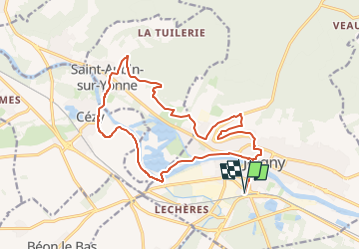

Length
17.8 km

Max alt
210 m

Uphill gradient
332 m
Km-Effort
22 km

Min alt
70 m

Downhill gradient
332 m
Boucle
Yes
Creation date :
2024-08-31 17:10:26.313
Updated on :
2024-08-31 17:10:52.374
5h02
Difficulty : Very difficult

FREE GPS app for hiking
 SityTrail
IGN / Geographical institutes
SityTrail Plus
The world is yours!
About
Trail Walking of 17.8 km to be discovered at Bourgogne-Franche-Comté, Yonne, Joigny. This trail is proposed by olivieraron.
Description
version améliorée pour 2024
Positioning
Country:
France
Region :
Bourgogne-Franche-Comté
Department/Province :
Yonne
Municipality :
Joigny
Location:
Unknown
Start:(Dec)
Start:(UTM)
529311 ; 5313497 (31T) N.
Comments