


ballancourt 2024

godmer
User
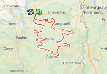

Length
44 km

Max alt
153 m

Uphill gradient
755 m
Km-Effort
54 km

Min alt
70 m

Downhill gradient
756 m
Boucle
Yes
Creation date :
2024-09-01 06:13:28.263
Updated on :
2024-09-01 10:06:14.535
3h52
Difficulty : Very difficult

FREE GPS app for hiking
 SityTrail
IGN / Geographical institutes
SityTrail Plus
The world is yours!
About
Trail Mountain bike of 44 km to be discovered at Ile-de-France, Essonne, Ballancourt-sur-Essonne. This trail is proposed by godmer.
Positioning
Country:
France
Region :
Ile-de-France
Department/Province :
Essonne
Municipality :
Ballancourt-sur-Essonne
Location:
Unknown
Start:(Dec)
Start:(UTM)
455092 ; 5374547 (31U) N.
Comments