


stavelot

jfmartin1978
User
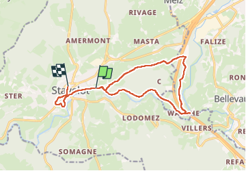

Length
13.3 km

Max alt
428 m

Uphill gradient
293 m
Km-Effort
17.2 km

Min alt
272 m

Downhill gradient
283 m
Boucle
No
Creation date :
2024-09-01 09:16:12.715
Updated on :
2024-09-01 12:20:58.093
3h04
Difficulty : Difficult

FREE GPS app for hiking
 SityTrail
IGN / Geographical institutes
SityTrail Plus
The world is yours!
About
Trail Walking of 13.3 km to be discovered at Wallonia, Liège, Stavelot. This trail is proposed by jfmartin1978.
Positioning
Country:
Belgium
Region :
Wallonia
Department/Province :
Liège
Municipality :
Stavelot
Location:
Unknown
Start:(Dec)
Start:(UTM)
709251 ; 5586688 (31U) N.
Comments