


Gaudissart Saint-Veran

pb07
User

Length
14.1 km

Max alt
2106 m

Uphill gradient
382 m
Km-Effort
19.2 km

Min alt
1820 m

Downhill gradient
384 m
Boucle
Yes
Creation date :
2024-09-01 07:00:13.11
Updated on :
2024-09-01 12:37:55.042
4h40
Difficulty : Very difficult

FREE GPS app for hiking
 SityTrail
IGN / Geographical institutes
SityTrail Plus
The world is yours!
About
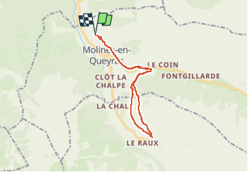
Trail Walking of 14.1 km to be discovered at Provence-Alpes-Côte d'Azur, Hautes-Alpes, Molines-en-Queyras. This trail is proposed by pb07.
Positioning
Country:
France
Region :
Provence-Alpes-Côte d'Azur
Department/Province :
Hautes-Alpes
Municipality :
Molines-en-Queyras
Location:
Unknown
Start:(Dec)
Start:(UTM)
328937 ; 4956012 (32T) N.
Comments