


salle la source / onet village

chantal12
User
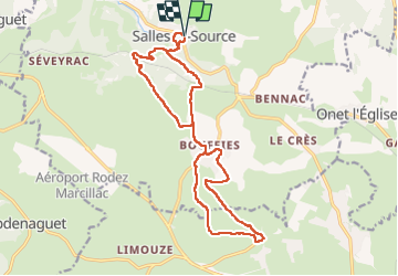

Length
18.5 km

Max alt
627 m

Uphill gradient
401 m
Km-Effort
24 km

Min alt
385 m

Downhill gradient
401 m
Boucle
Yes
Creation date :
2024-09-02 06:34:22.09
Updated on :
2024-09-02 12:23:53.798
4h44
Difficulty : Easy

FREE GPS app for hiking
 SityTrail
IGN / Geographical institutes
SityTrail Plus
The world is yours!
About
Trail Walking of 18.5 km to be discovered at Occitania, Aveyron, Salles-la-Source. This trail is proposed by chantal12.
Description
Randonnée faite le 2 septembre 2024.
Départ de Salle la Source en suivant le GR 62 jusqu'à Onet village. Retour par des chemins non balisés mais praticables.
Positioning
Country:
France
Region :
Occitania
Department/Province :
Aveyron
Municipality :
Salles-la-Source
Location:
Unknown
Start:(Dec)
Start:(UTM)
461382 ; 4920492 (31T) N.
Comments