


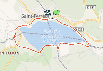
lac saint Ferréol

Mamilaure
User

Length
5 km

Max alt
372 m

Uphill gradient
61 m
Km-Effort
5.8 km

Min alt
330 m

Downhill gradient
65 m
Boucle
Yes
Creation date :
2024-09-02 12:07:00.74
Updated on :
2024-09-02 14:03:37.34
1h29
Difficulty : Easy

FREE GPS app for hiking
 SityTrail
IGN / Geographical institutes
SityTrail Plus
The world is yours!
About
Trail Walking of 5 km to be discovered at Occitania, Tarn, Sorèze. This trail is proposed by Mamilaure.
Positioning
Country:
France
Region :
Occitania
Department/Province :
Tarn
Municipality :
Sorèze
Location:
Unknown
Start:(Dec)
Start:(UTM)
421425 ; 4810178 (31T) N.
Comments