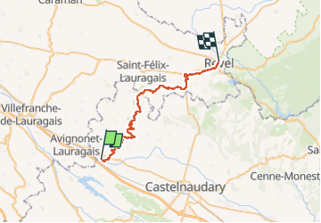
Trail Walking Montferrand - Naurouze. -  Revel - Photo

Naurouze. - Revel

© OpenStreetMap contributors
Length
Length
35 km
Max alt
Max alt
233 m
Uphill gradient
Uphill gradient
224 m
Km-Effort
Km-Effort  
38 km
Min alt
Min alt
195 m
Downhill gradient
Downhill gradient
208 m
Boucle
Boucle
No
Creation date :
2024-09-02 07:51:59.577
Updated on :
2024-09-02 15:52:40.171

(0 Reviews)

Walking
Walking
6h13
Difficulty : Difficult

Scan this QR Code to open this trail in the SityTrail application

FREE GPS app for hiking

Logo SityTrail SityTrail

IGN / Geographical institutes

Download SityTrail from the App Store Download SityTrail from Google Play

Logo SityTrail SityTrail Plus

The world is yours!

Download SityTrail from the App Store Download SityTrail from Google Play Download SityTrail on Huawei AppGallery

About

Trail Walking of 35 km to be discovered at Occitania, Aude, Montferrand. This trail is proposed by Alain28/01.

Description

Magnifique chemin le long de la rigole.Tout en haut le soleil généreux pour la lumière, d'un côté un alignement continu de platanes, de chênes et de pins, de l'autre l'eau de la rigole pour la fraîcheur et au sol de la terre battue,un peu d'herbe rase ou un tapis d'aiguilles pour le confort du marcheur.

Elevation profile

Positioning

Country:
France
Region :
Occitania
Department/Province :
Aude
Municipality :
Montferrand
Location:
Unknown
Start:(UTM)
404625 ; 4800450 (31T) N.


Close
My subscriptions