


GR 4 Egliseneuve Lugarde

taguette
User
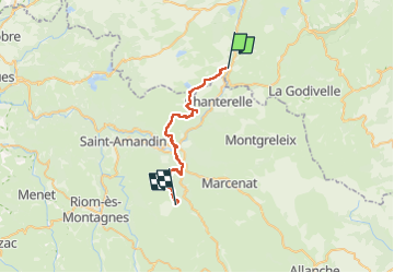

Length
27 km

Max alt
1103 m

Uphill gradient
714 m
Km-Effort
36 km

Min alt
700 m

Downhill gradient
654 m
Boucle
No
Creation date :
2024-09-03 05:34:44.395
Updated on :
2024-09-03 12:18:34.122
6h42
Difficulty : Very difficult

FREE GPS app for hiking
 SityTrail
IGN / Geographical institutes
SityTrail Plus
The world is yours!
About
Trail Walking of 27 km to be discovered at Auvergne-Rhône-Alpes, Puy-de-Dôme, Égliseneuve-d'Entraigues. This trail is proposed by taguette.
Positioning
Country:
France
Region :
Auvergne-Rhône-Alpes
Department/Province :
Puy-de-Dôme
Municipality :
Égliseneuve-d'Entraigues
Location:
Unknown
Start:(Dec)
Start:(UTM)
486372 ; 5028244 (31T) N.
Comments