


0409

maxEA65
User
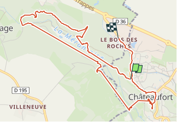

Length
6.6 km

Max alt
160 m

Uphill gradient
117 m
Km-Effort
8.1 km

Min alt
105 m

Downhill gradient
106 m
Boucle
No
Creation date :
2024-09-04 07:02:35.066
Updated on :
2024-09-04 08:28:25.029
1h25
Difficulty : Medium

FREE GPS app for hiking
 SityTrail
IGN / Geographical institutes
SityTrail Plus
The world is yours!
About
Trail Walking of 6.6 km to be discovered at Ile-de-France, Yvelines, Châteaufort. This trail is proposed by maxEA65.
Positioning
Country:
France
Region :
Ile-de-France
Department/Province :
Yvelines
Municipality :
Châteaufort
Location:
Unknown
Start:(Dec)
Start:(UTM)
432856 ; 5398723 (31U) N.
Comments