


Lac de Roue

pb07
User
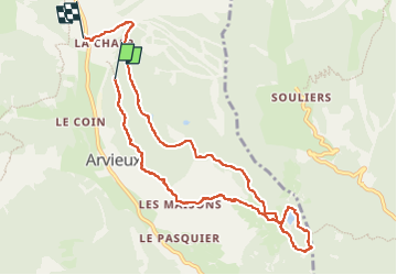

Length
10.1 km

Max alt
1929 m

Uphill gradient
314 m
Km-Effort
14.5 km

Min alt
1681 m

Downhill gradient
370 m
Boucle
No
Creation date :
2024-09-04 07:51:33.737
Updated on :
2024-09-04 13:32:51.506
2h56
Difficulty : Difficult

FREE GPS app for hiking
 SityTrail
IGN / Geographical institutes
SityTrail Plus
The world is yours!
About
Trail Walking of 10.1 km to be discovered at Provence-Alpes-Côte d'Azur, Hautes-Alpes, Arvieux. This trail is proposed by pb07.
Positioning
Country:
France
Region :
Provence-Alpes-Côte d'Azur
Department/Province :
Hautes-Alpes
Municipality :
Arvieux
Location:
Unknown
Start:(Dec)
Start:(UTM)
321157 ; 4960662 (32T) N.
Comments