


Le Mercou L'Asclier

ARVIEU
User
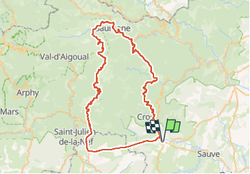

Length
87 km

Max alt
904 m

Uphill gradient
1937 m
Km-Effort
112 km

Min alt
158 m

Downhill gradient
1934 m
Boucle
Yes
Creation date :
2024-09-07 05:31:22.427
Updated on :
2024-09-07 05:33:31.19
5h00
Difficulty : Difficult

FREE GPS app for hiking
 SityTrail
IGN / Geographical institutes
SityTrail Plus
The world is yours!
About
Trail Cycle of 87 km to be discovered at Occitania, Gard, Saint-Hippolyte-du-Fort. This trail is proposed by ARVIEU.
Description
St Hippolyte du Fort Colognac le Mercou l'Estréchure les Plantiers l'Asclier Sumène (ou St Roman de Codières) St Hippolyte du Fort
Positioning
Country:
France
Region :
Occitania
Department/Province :
Gard
Municipality :
Saint-Hippolyte-du-Fort
Location:
Unknown
Start:(Dec)
Start:(UTM)
569134 ; 4867580 (31T) N.
Comments