


St jean 7 9 24

gillesmanfredi
User
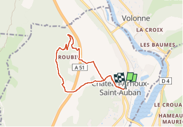

Length
7.1 km

Max alt
621 m

Uphill gradient
171 m
Km-Effort
9.4 km

Min alt
448 m

Downhill gradient
179 m
Boucle
Yes
Creation date :
2024-09-07 17:16:40.374
Updated on :
2024-09-07 18:14:18.24
57m
Difficulty : Easy

FREE GPS app for hiking
 SityTrail
IGN / Geographical institutes
SityTrail Plus
The world is yours!
About
Trail Trail of 7.1 km to be discovered at Provence-Alpes-Côte d'Azur, Alpes-de-Haute-Provence, Château-Arnoux-Saint-Auban. This trail is proposed by gillesmanfredi.
Positioning
Country:
France
Region :
Provence-Alpes-Côte d'Azur
Department/Province :
Alpes-de-Haute-Provence
Municipality :
Château-Arnoux-Saint-Auban
Location:
Unknown
Start:(Dec)
Start:(UTM)
260613 ; 4886598 (32T) N.
Comments