


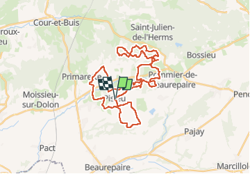
Pisieu 2024

marc6262
User

Length
46 km

Max alt
501 m

Uphill gradient
946 m
Km-Effort
59 km

Min alt
334 m

Downhill gradient
950 m
Boucle
Yes
Creation date :
2024-09-01 05:56:21.602
Updated on :
2024-09-08 15:34:24.391
3h09
Difficulty : Medium
3h00
Difficulty : Medium

FREE GPS app for hiking
 SityTrail
IGN / Geographical institutes
SityTrail Plus
The world is yours!
About
Trail Mountain bike of 46 km to be discovered at Auvergne-Rhône-Alpes, Isère, Pisieu. This trail is proposed by marc6262.
Description
Randonnée proposée par le club de Pisieu
Beaucoup de Single très peu de bitume
À recommander sans hésiter
Positioning
Country:
France
Region :
Auvergne-Rhône-Alpes
Department/Province :
Isère
Municipality :
Pisieu
Location:
Unknown
Start:(Dec)
Start:(UTM)
661556 ; 5027959 (31T) N.
Comments