


laboule Loubaresse

Clo0413
User
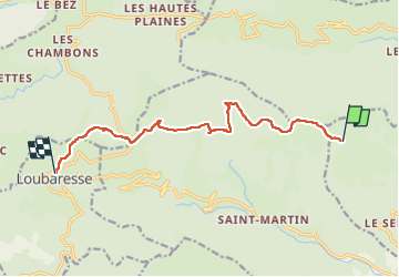

Length
11.1 km

Max alt
1458 m

Uphill gradient
268 m
Km-Effort
15.2 km

Min alt
1218 m

Downhill gradient
426 m
Boucle
No
Creation date :
2024-09-09 09:56:45.432
Updated on :
2024-09-09 14:41:37.147
3h08
Difficulty : Difficult

FREE GPS app for hiking
 SityTrail
IGN / Geographical institutes
SityTrail Plus
The world is yours!
About
Trail Walking of 11.1 km to be discovered at Auvergne-Rhône-Alpes, Ardèche, Laboule. This trail is proposed by Clo0413.
Positioning
Country:
France
Region :
Auvergne-Rhône-Alpes
Department/Province :
Ardèche
Municipality :
Laboule
Location:
Unknown
Start:(Dec)
Start:(UTM)
590431 ; 4940029 (31T) N.
Comments